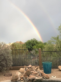
Mrs THC snapped this photo on Monday afternoon. We were driving (about 10 minutes from home) when we saw this storm to the northwest of edge of the Phoenix metro area. It's typical of what happens in July, August, and September during the monsoon season here, when the wind switches around to the south and southwest and brings up moisture laden water from the Gulf of California where it collides with the heated summer air of Arizona. Storms build up in the afternoon in the mountains surrounding Phoenix and then start moving through the area.
June saw endless cloudless days with temperatures as high as 122 downtown and 118 even where we live about 1000 feet above downtown, with afternoon humidity below 10% (and as low as 3%). At its worst, it's like being inside a pizza oven. On July 10 everything changed. Humidity began to rise with afternoon lows between 30% and 50%, we saw more and more clouds, and average temperatures dropped by 10-15 degrees. Then came more frequent downpours of rain, lighting, rainbows, and dramatic sunsets.
Yesterday afternoon was the worst the metro area has seen so far. Huge 65,000 foot high thunderheads formed and moved through much of the area bringing rain, lightning and 60 mph winds. And that wasn't all. On the southern edge of the metro area we had a haboob; a several hundred high foot wall of wind blown sand moving across the land. Real Biblical stuff. Below is a photo of a haboob (not today's).
Below are some photos Mrs THC took from our place in the aftermath of yesterday's action.


No comments:
Post a Comment