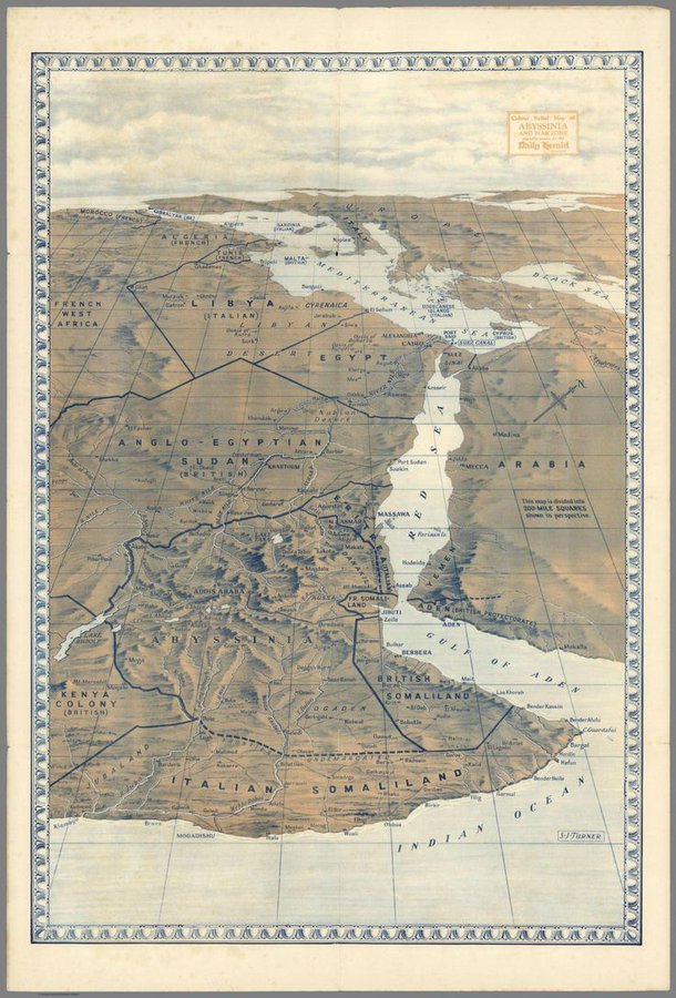
The unusual perspective; an aerial view from high above the Indian Ocean just off the Horn of Africa.
The way it emphasizes topography, particularly the mountains of Abyssinia (Ethiopia) and of the southwestern corner of the Arabian Peninsula. No surprise as they were once joined before the continents drifted apart and the Red Sea formed.
The representation of the final gasp of the colonial era. Abyssinia had been conquered by Italy in a 1935-36 campaign launched from its existing colonies in Somaliland and Eritrea. The British ruled British Somaliland, Kenya, and the Anglo-Egyptian Sudan. Though Egypt was nominally independent it was actually run by the British. And off to the northwest is the vast expanse of French West Africa.
The portrayal of the pivotal cockpit of conflict between the Ottomans and Portuguese during the 16th century, a subject covered in a couple of recent THC posts.
Best of all, if you look closely, about a 1/4 of the way up from the south end of the Red Sea you will see the Farasan Islands designated, the location of the Roman garrison which was the subject of the THC post, The Farthest Outpost.
It seems we've had quite a bit of serendipity recently regarding the topic of the Indian Ocean, leading to three posts.
No comments:
Post a Comment