Located in the United Kingdom, Avebury is not as well known outside England as its neolithic cousin, Stonehenge, which is twenty miles to the south. Today, Avebury is a small village that looks the same as it did when THC and friends were there in 1978. We were in the midst of a bicycle tour which started with us embarking from London on the train with our bicycles and disembarking in Oxford. We'd ridden up into the Cotswold Hills and then headed south via Cirencester to Avebury. After Avebury, we headed to Winchester where my friends took a train back to London and I headed west for the Mendip Hills, Glastonbury and Bath.
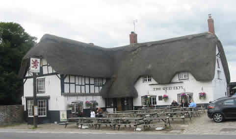
When we arrived in Avebury late that afternoon, we inquired at the local pub, The Red Lion, located where the roads intersect in the center in the photo above) whether there was a B&B in the village. We were informed that there was but the lady who ran it was not taking in boarders at this time, though we were given directions to our home down the street and told we were welcome to talk with her. I don't remember her name (though I do remember she had red hair) and though she confirmed what we were told in the pub, she seemed to realize we have few alternatives and decided to take us in. I think we paid $7 a night.
 (The Avebury pub from londontoolkit.com)
Over the next couple of days we explored the Avebury stone circle, walked up to the ancient Ridgeway Track looming above the village, saw West Kennet Long Barrow and visited the mysterious Silbury Hill. I seem to also remember we met some bloke at the Red Lion who took us back to his place to listen to music and drink more beer.
Avebury was constructed during the third millennium BC. It's a henge consisting of a large circular bank, about 1,100 yards in circumference, along with an internal ditch perhaps 12-15 meters wide the outlines of which can be seen in the picture at the top. Within the henge is a large stone circle.

(from Gazette and Herald UK)
Leaving the henge in a southeasterly direction is a 2.5 kilometer long thoroughfare bordered by large stones (only a few of which remain), known today as West Kennet Avenue and traces of a similar avenue leading to the southwest have also been found.
Lying to the southeast, about 1 1/2 miles from the village, Silbury Hill is a 131 foot high artificial hill, constructed of chalk rubble and earth a bit earlier than the Avebury circle. The purpose of Silbury Hill as well as the rest of the Avebury complex remains a riddle, but the amount of labor and time required to construct all of it would have been enormous and indicates the agricultural society of that time had enough wealth and central authority to commit such a large amount of its resources to a generations long project.
(Silbury Hill from dorwynmanor)
Below is a sketched reconstruction of the original monument by the 18th century antiquarian William Stukeley, who played a key role in saving what was left. (From ancient-wisdom.com)
No comments:
Post a Comment