Came across this remarkable 1850 photo of Rome.
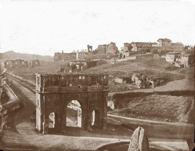
It looks like it is taken from inside the Colosseum, probably on its second level, and it pictures the area to the west of the structure. The stone sticking up in the lower right center is the remnant of the Meta Sudans, which was bulldozed at Mussolini's order. Directly center is the Arch of Constantine (constructed in the early 4th century). The modern road has been rerouted so it passes around, not through, the Arch. Further down that road on the right is part of the aqueduct that carried water to the Palatine Hill. The elevated ground in the distance behind the aqueduct is the Aventine Hill and the valley in between is where the Circus Maximus was located.
The upper center-right of the photo is dominated by the Palatine Hill, home of the Imperial Palace. During the time of the empire it was almost completely covered by palace buildings. In 1850 the highest point has a monastery on it though you can see remnants of the palace as the hill slopes down to the aqueduct. If you could see 90 degrees to your right the Sacred Way leading to the Forum would appear.
The other thing to note is how much of the hill was devoted to agriculture and pasture. After the 6th century Gothic Wars, this area and much of the rest of the former imperial city ceased to be a place of dense urban habitation. From Belisarius Enters Rome:
Large tracts of the ancient city, including the Forums, the hills (including the Palatine on which the Imperial Palace was sited), and the area around the Colosseum, were mostly abandoned except for the farms and vineyards that had sprung up among the ruins and for the churches and monasteries scattered among the ruins, most prominently the Lateran in the far southeast of the walled city, which until the 15th century was the seat of the Papacy; an area known as the disabitato.
This is what the area between the amphitheater and the Lateran looked like in 1870. Today it a busy and congested part of the city.

The disabitato existed into the 19th century with the expansion of the city into the Rome we know today only after the reunification of Italy in 1870. The remaining densely populated part of the city was located on the Tiber in what was called the Campus Martius at the time of the Republic and Empire and on the other side of the river in the area near what became the Vatican in the Middle Ages.
At the time the photo was taken the population of the entire city was probably around 150,000 to 175,000 compared to about a million in 150 AD. It was not until the 1930s that Rome's population exceeded that of the Second Century AD.
The photographer was Ludovico Tuminello (1824-1907).
Those images are remarkable!
ReplyDelete