I've posted about Irving Finkel of the British Museum before. Here he is expounding his theory that a discovery at Gobekli Tepe in Anatolia proves that writing was developed several thousand years before previously thought. He also explains that significance that the ancient writing we do have from Mesopotamia provides a very narrow, and perhaps misleading, window onto that world.
Finkel is always entertaining and has a knack for explaining complex topics in an understandable way. I have no idea if his theory is correct but you'll enjoy listening to him.
After an absence of over a thousand years, the colossal (42.6 feet high) statue of the Emperor Constantine, is complete and back in Rome, having just been unveiled in the garden of the Capitoline Museum, overlooking the Roman Forum.
Constantine, born around 280, spent from 306 to 312 maneuvering to seize control of the western portion of the Roman empire. In 312 he defeated the Emperor Maxentius at the Battle of the Milvian Bridge outside of Rome, and sometime in the next few years the statue was completed and placed in the Basilica of Maxentius, located between the Forum and the Colosseum. According to Wikipedia:
The great head, arms and legs of the Colossus were carved from
white marble, while the rest of the body consisted of a brick core and
wooden framework, possibly covered with gilded bronze.
The statue was pillaged during the early Middle Ages although various portions of the statue have been preserved and ended up in different Italian museums. I'd seen the head and other fragments during my visit to the Capitoline in 2006.
(Statue fragments)
The unveiled statue is a recreation that, according to this AP article:
. . . was imagined using 3D modelling technology from scans of the nine giant original marble body parts that remain.
Constantine went on to defeat Licinius, his rival in the East, in 324, reuniting the empire under one ruler. Before his death he began the construction of a new capitol, modestly called Constantinople, and accepted baptism as a Christian on his deathbed.
I've always been fascinated by the frontiers of the Roman Empire; exhibits of the vastness of its lands and the remoteness of its farthest outposts. We've explored the southeastern frontier in The Farthest Outpost and Madain Saleh, the northwest in Barates At The End Of The World, and along the crumbling northern frontier during the late 5th century (The Life Of St Severinus). Let us turn our gaze to the southwest, to the Atlantic coast of north Africa.
(By Volubilis_panorama.jpg: Иерей Максим Массалитинderivative work: Prioryman - This file was derived from: Volubilis panorama.jpg:, CC BY-SA 2.0, https://commons.wikimedia.org/w/index.php?curid=22418406)
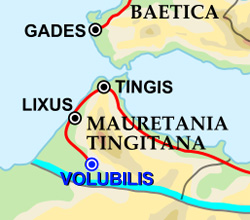
Located on a ridge above a fertile plain near the present city of Meknes, Volubilis, founded in the third century BC was part of the Kingdom of Mauretania which occupied lands now part of Morocco and Algeria. After Rome's destruction of Carthage in 146 BC, Mauretania became a Roman client kingdom, and in the reign of Augustus, Volubilis became its capital. The Emperor Claudis annexed the kingdom in 44 AD, initiating an era of prosperity for Volubilis, as it grew to cover 100 acres with 1.6 miles of protective walls, and becoming a major producer of olive oil, a highly valued commodity across the empire.
At its peak in the second century AD the city may have had 20,000 inhabitants and was described by the geographer Pomponius Mela as one of "the wealthiest cities, albeit the wealthiest among small ones" in the province. Like most Romanized cities, the majority of the inhabitants were of local origin, in this case Berber, though Latin was the common language. Again, like most prosperous Roman cities, the remains of many villas owned by the wealthier citizens are found on its outskirts.
Throughout its history as part of the empire, Volubilis remained threatened by unconquered mountain Berber tribes and there is evidence of Roman cavalry and infantry cohorts from Hispania, Gaul, Belgia, and Syria stationed in the forts surrounding the city.
It was only with the empire's turmoil in the late 3rd century, that Rome withdrew from Volubilis, maintaining garrisons only in a limited coastal stretch to the north near present day Tangiers (for more on this period seeDiocletian Has A Very Good Day).
Volubilis remained occupied after Rome's retreat and for the next century there is evidence of new construction, new mosaics, continuing chariot races, and Latin usage. After an earthquake in the late 4th century, the city slowly shrank though it remained the center of a Christian population until its final abandonment in the 11th century.
Today it remains abandoned, a reminder of the reach of Rome, and aUNESCO World Heritage Site.
Painting by Giovanni Canaletto, a Venetian, who visited Rome in the 1720s.
Just to the right of the Arch can be seen part of the Colosseum. The Arch was constructed in the early 4th century after the Constantine the Great's defeat of his rival Maxentius at the Battle of the Milvian Bridge in 312, just outside of Rome. It was the last triumphal monument of the Rome Empire constructed in the city. Even by that time the quality of monumental art had declined, with many of the statutes and facades of the Arch scavenged from monuments of prior centuries.
Within two centuries the city entered a period of sharp decline with the monuments, building, and palaces of the empire no longer being maintained and, in most instances, having their marble cladding removed or sometimes the very structure being dissembled for use elsewhere.
The city proper retreated to the banks of the Tiber with many of the outlying areas, including the former Forum and the area around the Colosseum left to decay, surrounded by agricultural lands, vineyards, gardens, and occasional churches, monasteries, villas, and strongholds for the quarreling families that dominated local politics for centuries. For more on this period read Belisarius Enters Rome, which occurred on December 9, 536.
As late as 1870 much open land remained south of the Colosseum.
Beneath the English Channel and North Sea is a lost world that may reveal new information on the spread of homo sapiens in northern Europe.
The area in yellow and orange below was dry land during the last Ice Age when sea levels were much lower worldwide. As you can see ,what is now England, Wales, and Scotland was connected to Ireland, the Hebrides, and the Orkneys and all had a land connection with France, Belgium, Holland, Germany and Denmark. The extent boundaries varied with sea levels from 20,000 years ago until about 6500 BC when the ocean finally swept away the land connections.
Doggerland takes it name from the Dogger Banks, shallow shoals in the North Sea and renowned fishing grounds, named by the Dutch in the 17th century. The Dogger Banks were also the location of a bizarre incident in October 1904 when the Russian Fleet, proceeding from St Petersburg to the Pacific, believed itself under attack by the Japanese Navy and opened fire on what turned out to be British fishing boats, killing three fishermen and almost triggering a war between Russia and England. The Russian fleet eventually completed its epic voyage and was promptly sunk by the Japanese Navy off the coast of Korea at the Battle of Tsushima. So there.
The ancient Doggerland was an expanse of low grasslands, meadows, rivers, and swamps and home to many Neolithic human settlements. Recent university explorations, with the assistance of the oil companies active in the North Sea, are revealing more about early human activities, with the prospect of much more information coming to light in the future.




 Just to the right of the Arch can be seen part of the Colosseum. The Arch was constructed in the early 4th century after the Constantine the Great's defeat of his rival Maxentius at the Battle of the Milvian Bridge in 312, just outside of Rome. It was the last triumphal monument of the Rome Empire constructed in the city. Even by that time the quality of monumental art had declined, with many of the statutes and facades of the Arch scavenged from monuments of prior centuries.

 As you can see ,what is now England, Wales, and Scotland was connected to Ireland, the Hebrides, and the Orkneys and all had a land connection with France, Belgium, Holland, Germany and Denmark. The extent boundaries varied with sea levels from 20,000 years ago until about 6500 BC when the ocean finally swept away the land connections.